Mining Subsidence
Monitor effects of mining activities on surrounding areas.
Monitoring subsidence in the surrounding area during mining projects is crucial for ensuring the safety and stability of both human-made structures and natural systems.
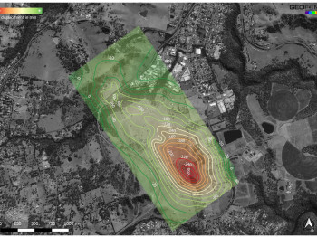
In this case, where the effects of longwall mining operations over a large area needed to be determined, InSAR proved a powerful tool for conducting this analysis. By utilising satellite-borne radar systems, InSAR enables continuous and precise monitoring of subsidence over large areas with remarkable accuracy.
Unlike conventional in-situ monitoring, which typically cover limited, discreet points and sections, InSAR provides a comprehensive view of deformation across an expansive region. This capability is particularly valuable in mining projects where subsidence can have far reaching consequences.
The extent and magnitude of mining-induced settlement that coincided with mining operations in different areas were determined by InSAR analysis of a time series of satellite images.
Highlights
- Longwall mining-induced settlement over a large area needed to be determined.
- InSAR analysis (SBAS) was performed on a time series of satellite images.
- The extent and magnitude of subsidence and uplift were determined for a nearby industrial zone, road, and railway line.
- The pattern of movement coincided with the mining operations beneath.
- We validated against in situ monitoring by different contractor.