
5 Satellite Monitoring Capabilities Every Engineer Should Know About
- Geofem

- 6 days ago
- 4 min read
Satellite remote sensing is revolutionising the way we measure, monitor, and model Earth's dynamic systems. By capturing data across multiple spectral bands and at varying spatial and temporal resolutions, satellites provide insights that extend far beyond conventional aerial imagery.
Today, remote sensing underpins critical applications ranging from infrastructure monitoring and geospatial analysis to environmental management and disaster risk assessment.

Its ability to deliver consistent, large-scale observations makes it an indispensable tool for engineers, scientists, and decision-makers alike.
In this article, we explore five lesser-known aspects of satellite remote sensing, including how Interferometric Synthetic Aperture Radar (InSAR) is enabling high-precision measurement and monitoring of millimetre-scale ground deformation across the earth’s surface.
Fact 1: Satellite remote sensing goes beyond visible light
Unlike optical imaging systems, radar-based satellites actively emit microwave signals and measure the reflected response from the Earth's surface.
This enables data acquisition:
Day and night
Through cloud cover
In the presence of smoke, haze, and adverse weather conditions
As a result, Synthetic Aperture Radar (SAR) has become a critical technology for continuous monitoring of transport infrastructure, the built environment, mining operations and disaster-affected areas where optical imagery may be unavailable or unreliable, providing timely and reliable data for risk assessment, infrastructure management, environmental monitoring and emergency response.

Fact 2: Satellites integrate data across multiple spectral bands for a complete understanding of physical processes
Modern earth observation satellites employ sensors operating across a range of wavelengths, each providing different information about surface conditions and environmental processes.
Key sensor technologies include:
Infrared sensors – Measure thermal characteristics and temperature variations, supporting applications such as urban heat mapping and environmental monitoring.
Microwave sensors (SAR) – Provide all-weather, day-and-night observations and are widely used for deformation monitoring and flood mapping.
Thermal infrared sensors – Detect emitted radiation, enabling the assessment of heat loss, surface temperatures, and thermal anomalies.
The ability to integrate data from multiple spectral bands provides engineers and geospatial professionals with a more complete understanding of physical processes occurring on the earth's surface.
Fact 3: Satellites can ‘see’ movements smaller than a fingernail
Interferometric Synthetic Aperture Radar (InSAR) – among the most advanced remote sensing techniques – can detect ground deformation with millimetre-level accuracy.
InSAR works by analysing changes in the phase of radar signals acquired by a satellite during successive passes over the same location. Regular revisit cycles support trend analysis and early detection of anomalies.
By comparing radar observations over time, it is possible to identify subtle surface displacements that would be impossible to detect through conventional visual inspection or standard optical imagery.
This capability enables the continuous monitoring of phenomena such as land subsidence, landslides, seismic deformation, and infrastructure-related ground movement.

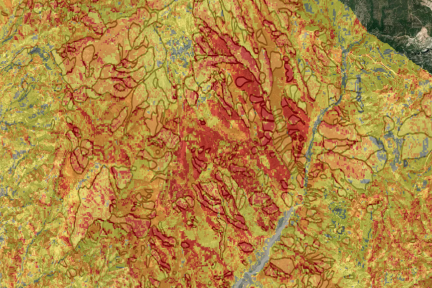

Fact 4: InSAR can reveal hidden ground deformation long before it becomes visible
The earth’s surface is in constant motion, with deformation often occurring well before any visible structural damage appears, making it a cost-effective method for identifying emerging geotechnical and structural risks early.
For engineers and infrastructure managers, this is particularly valuable in dynamic or high-risk environments where conditions evolve rapidly, and ground-based monitoring alone is insufficient or impractical.
InSAR is widely used to monitor:
Ground deformation and land subsidence
Landslides and slope instability
Earthquake-related ground movement
Structural movement of buildings and critical infrastructure
Bridges, dams, railways and road networks
Mining-induced deformation and tailings facilities
Groundwater extraction impacts
Urban development and construction-related settlement
Coastal erosion and shoreline change
Flood-prone areas and post-disaster ground movement
Environmental and geotechnical hazards across large geographic areas
In many cases, deformation signals precede observable surface impacts such as cracking or settlement, allowing earlier detection of developing ground and infrastructure risks.
Fact 5: Satellite observations enable high-frequency monitoring at regional to global scale
Modern satellite remote sensing systems deliver frequent, systematically acquired observations of the Earth's surface, enabling continuous time-series analysis of environmental and geophysical change across vast geographic areas.
By providing a consistent view across entire networks and regions, satellite observations help identify emerging risks, prioritise inspections and support more informed decision-making.
Wide-area coverage: Consistent observations enable the monitoring of both accessible and remote assets within a common reference framework, providing visibility across entire transport corridors, utility networks, mining operations and urban environments.
Network-level insight: Rather than assessing individual assets in isolation, engineers can evaluate how infrastructure performs across broader geographic areas, helping to detect patterns, trends and interconnected risks.
Scalable monitoring: Satellite monitoring can be seamlessly expanded from a single asset to regional or national-scale infrastructure portfolios without proportional increases in field deployment, personnel or equipment requirements.
Historical data: With access to more than a decade of archived satellite observations, engineers can analyse historical conditions, establish long-term baselines, identify gradual changes and investigate when and how environmental or geotechnical issues first emerged.
This inherent scalability makes satellite monitoring a cost-effective solution for organisations responsible for managing extensive infrastructure networks, enabling comprehensive situational awareness and long-term resilience planning at a scale that would be difficult to achieve through conventional monitoring methods alone.
Embracing the future of earth observation for confident, data-driven decisions
Satellite remote sensing, including InSAR, is now a key component of modern asset monitoring and geospatial risk assessment.
It enables engineers and infrastructure managers to continuously quantify ground and environmental change at scale, supporting the early identification of risks and more informed, proactive decision-making.
When integrated with ground-based measurements and existing asset data, satellite observations enhance situational awareness, improve predictive capability, and strengthen the evidence base for maintenance and investment decisions.
As data availability and processing capabilities improve, these technologies are becoming crucial tools for monitoring infrastructure performance, resilience, and risk management, increasingly integrated into decision-support workflows alongside in-situ data and numerical models.
At Geofem, we specialise in the geotechnical interpretation of satellite-derived data, supporting engineers and asset managers in the ongoing monitoring of infrastructure including railways, roads, bridges, mines, hydro dams, and more.
Get in touch with our team to explore how these insights can support your asset management and risk monitoring needs.


Comments