Don’t pay a claim until you have all the information. Weekly ground surface and structure movement data since 2014 with millimetric accuracy probably already exists for your case. Combined with our engineering expertise and experience it may be possible to reliably establish a cause.
While subsidence maps based on geological conditions already exist, we have combined these with actual subsidence data measured by satellite and other parameters using our geotechnical expertise to produce subsidence susceptibility maps with greater reliability and detail down to individual buildings.
While landslide susceptibility maps based on topography, geology and geomorphology already exist, they can be low-resolution, subjective and out of date due to climate change. We have combined these with actual movement data measured by satellite and other parameters using our geotechnical expertise to produce detailed maps. Not only do they provide susceptibility, but they also warn of possible imminent landslide so that remediation measures can be undertaken proactively and more cost effectively.
Sinkholes occur in certain geological conditions and their prevalence is increasing due to climate change. We assess the susceptibility of regions based on historical subsidence data and provide early warning of possible imminent sinkholes for proactive remediation and loss reduction.
Do you insure infrastructure such as roads, railways and utility services against damage and third-party liability? We provide reliable information on the condition and susceptibility of these assets to hazards such as landslide and subsidence and even offer an early warning system for possible imminent failure to allow proactive investigation and remediation to minimise losses.
Do you insure mining assets against damage and third-party liability? We provide reliable information on the condition and susceptibility of these assets to hazards such as tailings dam failure and even offer an early warning system for possible imminent failure to allow proactive investigation and remediation to minimise losses.
Do you insure Energy assets such as offshore platforms and pipelines against damage and third-party liability? We provide reliable information on the condition and susceptibility of these assets to hazards such as landslide and subsidence and even offer an early warning system for possible imminent failure to allow proactive investigation and remediation to minimise losses.
Do you investigate claims for polluting discharges by shipping? We use satellite data to identify the source and spread of marine pollutants.
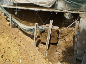
Back-analysis of basement construction by FEA revealed the cause of a collapse.
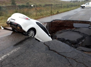
Learn how to get early warning of sinkholes.
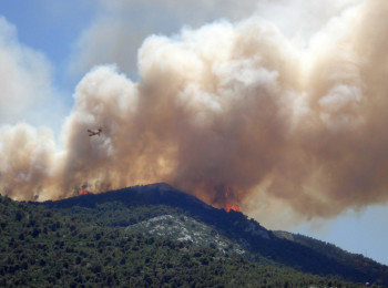
Manage forest fire risk with satellite data.