Are you still using static reports to manage your assets? Are you carrying out physical inspections to identify areas of concern? Our web-based GIS platform EYEGIS™ is here to provide an interactive way to access and visualise your data (in 2D and 3D) and asses the condition of your assets remotely.
With an extensive set of tools and functionality, EYEGIS™ can help you understand, analyse and share your results. Designed internally with the user in mind, our platform is secure, fast, intuitive and fully cloud based. It can be accessed from anywhere at any time – all you need is your login details and an internet connection.

Your EYEGIS
Our GIS platform EYEGIS™ is fully customizable and able to offer you the tools, features and look that fit your needs. You imagine it, we create it! And the best part is that no GIS expertise is required – it’s so intuitive that it can be used with minimal training.

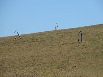
Cover your tracks
Learn how to get network-wide information on railway asset condition.
See Case Study

Customized GIS
What if we told you can now have a GIS in-house without any software? Harnessing our geospatial expertise, we are able to build a bespoke web-based, user-friendly, secure GIS platform where you can visualise and analyse your spatial data in an interactive way. Your platform can be based on our cloud or yours.
Where The Water Goes
Learn how an integrated GIS is leading to improved management of water supply assets.
See Case Study

GIS layers
GIS is all about data. But more data does not always mean more insight. Both our geotechnical engineering and satellite data analysis expertise give us the ideal combination to provide you with the information that makes sense to you. We use automated algorithms, AI techniques, statistical analysis and engineering insight to map your assets and track their performance.

Combining Data in GIS
There is no better way to combine and display location data than in a GIS environment.
See Case Study