Combining Data in GIS

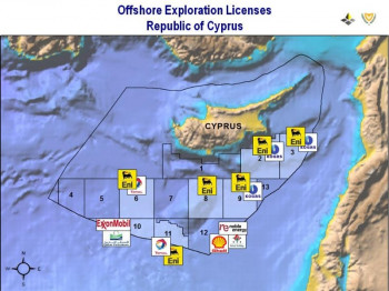
The utilisation of Geographic Information System (GIS) in enhancing the efficiency of mapping processes presents multifaceted advantages, as aptly demonstrated by the CSA in their application to ExxonMobil’s gas exploration drilling endeavours within the Cyprus Exclusive Economic Zone (EEZ). The intrinsic complexity of managing geospatial data extracted from various sources initially posed a challenge, leading to inefficiencies in the mapping process.
To address this hurdle and unlock the full potential of GIS, diverse data streams needed to be amalgamated into a unified GIS platform. This strategic consolidation not only streamlined the process of data integration, but also fostered a holistic environment for the optimal management of the entire exploration.
The consolidation GIS platform enabled real-time visualisation of critical geospatial information, empowering decision-makers with actionable insights. This timely access to information proved instrumental in refining the exploration strategy and adapting to dynamic operational requirements.
Moreover, the enhanced GIS platform offered spatial analysis that transcended traditional mapping methods. Georeferenced data layers facilitated the identification of spatial patterns, correlations, and trends that might have remained concealed within disparate datasets. By harnessing these analytical capabilities, potential challenges could be proactively anticipated, and the deployment of resources could be optimised.
Furthermore, the collaborative nature of the GIS platform nurtured effective communication and coordination among cross-functional teams involved in the gas exploration activities. Geographically dispersed stakeholders could seamlessly access, share, and update geospatial information in a syncronised manner. This facilitated a more cohesive approach to decision-making, minimising the risks of misaligned efforts.
In conclusion, the deployment of GIS technology was of enormous benefit in ExxonMobil’s Cyprus EEZ gas exploration operations. The amalgamation of diverse data sources into consolidated GIS platform not only rectified initial inefficiencies, but allowed for enhanced visualisation, spatial analysis, and informed decision-making.
Highlights
-
Collected data from different sources.
-
Incorporated the data into a unified GIS.
-
Enabled improved management of data.