Ring The Changes
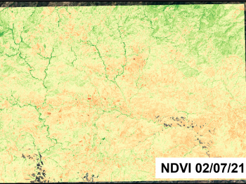
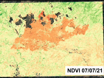
A wide array of temporal transformations are able to be detected by satellite. Among these transformations are urban expansion, construction projects, erosional shifts, sediment redistribution, and the far-reaching consequences of disasters. In this example, changes in vegetation health due to climate extremes and deforestation needed to be determined on the island of Cyprus.
The innovative algorithm we employed played a crucial role in precise quantification of vegetation alterations through NDVI (Normalised Difference Vegetation Index) analysis. These algorithms leveraged advanced mathematical and computational techniques to analyse satellite or drone-derived multispectral imagery. By extracting information from specific bands of light, NDVI algorithms can quantify the density and health of vegetation. They account for factors such as atmospheric interference and sensor variations, enhancing accuracy.
Our methodology spanned extensive geographical zones and captured temporal nuances over prolonged durations through meticulous scrutiny of satellite imagery.
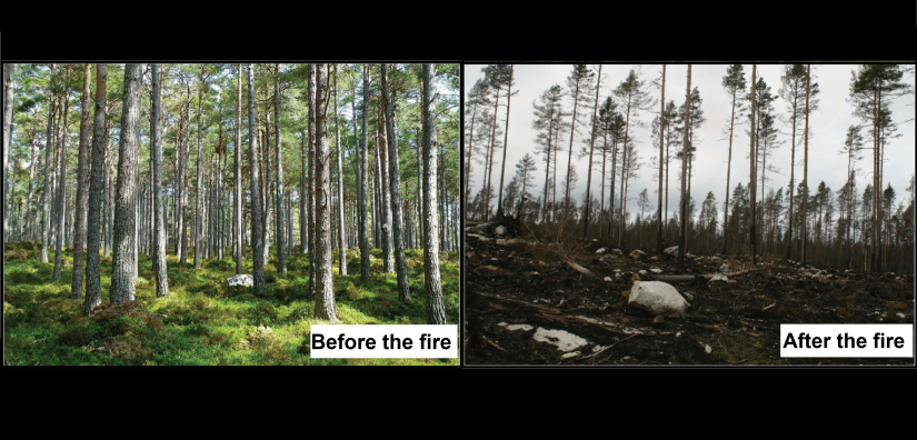
Furthermore, our advanced techniques demonstrated exceptional proficiency in accurately delineating the precise extent and magnitude of devastation caused by the catastrophic forest fire that rapidly swept across the entire island in July 2021. Through meticulous analysis of high-resolution satellite imagery and sophisticated algorithms, we were able to provide detailed spatial information, mapping the affected areas with precision. This comprehensive assessment not only facilitated a deeper understanding of the aftermath but also contributed valuable insights for effective disaster response, resource allocation, and future mitigation strategies to safeguard against such environmental crises.
Highlights
-
Large scale, remote monitoring of vegetation health.
-
The extent of damage from recent forest fires was also determined.
-
Other changes can be detected including urbanisation, construction, erosion and deposition.